| Back
to Location
Photo of Building MAPS: 5 Mile Radius Metro Area Parking Map Note: Please email
|
Map:
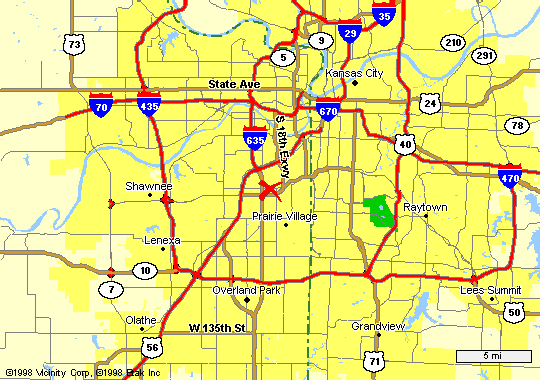
Metro Area Directions From: NORTHEAST- Independence WEST NORTH SOUTH -Olathe SOUTH EAST Grandview SE - LEE'S SUMMIT |
| Back
to Location
Photo of Building MAPS: 5 Mile Radius Metro Area Parking Map Note: Please email
|
Map:
Metro Area Directions From: NORTHEAST- Independence WEST NORTH SOUTH -Olathe SOUTH EAST Grandview SE - LEE'S SUMMIT |
|
Mission, KS 66202 |
or 831-SWNG |
 |
| From the West
- I-70 & I-435 the KANSAS Side
Continue traveling towards the East on I-70 to I-635 Turn South (right) on I-635 (I-635 turns into Metcalf after you pass over I-35) Stay on I-635/Metcalf turn East on Shawnee Mission Parkway (also W. 63rd St.) (to go East on Shawnee Mission Parkway- go UNDER the bridge & take the first right, around the cloverleaf and OVER the bridge you just went under) Take Shawnee Mission Parkway East to Lamar (the first light) Turn left on Lamar (North) Go past 61st St. to Martway Turn right on Martway to 6101 (it will be on your right- about a block down) See Photo of building. top/map |
| From the NORTHEAST
- Independence
the MISSOURI Side of I-70 & I-435 Travel on I-70 towards the West (towards Kansas) You will see a sign for Topeka and Wichita with various highways, including I-35 Stay in the far left lane when approaching the downtown loop (you'll be going into the southern part of the loop) You can stay in the same lane throughout the loop - follow the signs for I-35 South (Wichita) Continue to follow the signs for I-35 South You will cross the State Line into Kansas (no exit) & pass a few exits before reaching LAMAR You will need to be in the far RIGHT lane to Exit at Lamar (right lane exit) Turn South (left) on Lamar -past 55th keep traveling on Lamar then Turn East (left) on MARTWAY (MARTWAY is the first turn after Johnson Drive) (Johnson Drive is about 59th St.) to 6101 Martway (it will be on your right- about a block down) See Photo of building.top/map |
| From the SOUTHEAST
- Grandview area
Take Hiway 71 North to I-435 (you'll exit to the right - then take the left lane to I-435 going WEST) Travel West on I-435 to Metcalf Turn North (right) on Metcalf You will travel about 15 minutes until you Turn East (right) on Shawnee Mission Parkway (63rd Street) Turn North (Left) on Lamar Turn East (right) on Martway to 6101 Martway (it will be on your right- about a block down) See Photo of building. top/map |
| From the SOUTHEAST
-Lee's Summit/South Raytown
Take 50 hiway to I-470 Travel West on I-470 to I-435 West Travel West on I-435 to Metcalf Turn North (right) on Metcalf You will travel about 15 minutes until you Turn East (right) on Shawnee Mission Parkway (63rd Street) Turn North (Left) on Lamar Turn East (right) on Martway to 6101 Martway (it will be on your right- about a block down) See Photo of building. top/map |
| From the NORTH
- I-29
Turn South (right) on I-635 (I-635 changes to Metcalf after you pass over I-35) Stay on I-635/Metcalf turn East on Shawnee Mission Parkway (also W. 63rd St.) (to go East on Shawnee Mission Parkway- go UNDER the bridge & take the first right, around the cloverleaf and OVER the bridge you just went under) Take Shawnee Mission Parkway East to Lamar (the first light) Turn left on Lamar (North) Go past 61st St. to Martway Turn right on Martway to 6101 (it will be on your right- about a block down) See Photo of building. top/map |
| From the SOUTH
(Olathe - South I-35 or 69)
Travel North to Shawnee Mission Parkway Turn East (right) on Shawnee Mission Parkway Turn North (Left) on Lamar Turn East (right) on Martway to 6101 Martway (it will be on your right- about a block down) See Photo of building. top/map |